NEW for 2020! Victoria Air Photos NOW Offering Precision Agriculture Drone Services!
We are looking for new clients to join our customer service list at this time.
Simplify Aerial Scouting - Saving you Time and Money!
According to Gasparic, “Multi-spectral (precision agriculture) has the promise to transform the agriculture and land management industries by collecting precise plant-level data without having to send personnel into the field for manual surveys.”
"By 2050 we will need to double the amount of food production to feed everyone on the planet. The constraint is that we only have 30% more land to grow on. Growers efficiency has to increase substantially. Drones and their data systems can be a big part of that." John Stone, Product Line Drone Manager, 2016
In the early days of drones, it was ‘Here’s your drone and a pretty image that shows a bad spot.’ But a farmer already knows where his bad spots are. What he doesn’t know is when they are going to pop up during the season. Now, we can see exactly when the issue is starting and how big it is, then create a plan to fix it.
Justin Metz, Technology Integration, Bowles Farming Company

Victoria Air Photos and Survey since 2013 is now offing a new, powerful, tried and tested precision agricultural (PA) service using the best, and most efficient drone systems and software available. We use conventional multi-rotors and now offer hybrid mapping services as well.
"At VAP, we have the right experience (approx 2000 hours RPAS flight time logged), Transport Canada certification, knowledge and equipment to make this work fast." David Carlos. Owner VAP

Our new, exciting, state of the art hybrid drone operates quieter, faster, higher and with way more efficiency than traditional quad-copters and with better results.
This drone is 100% built in the USA and customized in Canada by VAP with military-grade, cutting-edge technology.
Cost-effective PA is the way of the future whether you own a golf course, a 400 acre produce farm, or a vineyard looking to scale your business.
This proven technology means not only savings on costs, but much less of an environmental impact including unnecessary fertilizer runoff, excess waste of assets, perspiration products and water resources.
"Normalized difference vegetation index (NDVI) is one of the most important vegetation indices in crop remote sensing!" See full article on Quantitative monitoring here.
Week by week, or month by month, you can scale, compare and plan with PA drone flights & analytics. You will be able to detect problems over a wide or small area long before the human eye.
2D and 3D Maps. In addition to multi-spectral maps, you will also have access to high-resolution RGB colour photos and maps stitched together of the entire area for viewing, analysis or presentation.

Intelligent Green Production
"In the agricultural world of production where knowledge powers our decisions, maximizing every acre requires a tool to know every acre".
![]() Victoria Air Photos has the answer with an awesome tool that makes up a new, intellegent and powerful integrated drone and data eco-system!
Victoria Air Photos has the answer with an awesome tool that makes up a new, intellegent and powerful integrated drone and data eco-system!
We Fly and View Crop Health simultaneously with instant feedback on the field
- - Fully functional and safe flight operations. Simply define field area to be covered and the pilot system does the rest
- - Scout 50 acres in 5 minutes, 200 acres in 22 minutes or 400 acres in 45 minutes in a single flight!
- - Dual built-in 18 megapixel cameras - No need to swap or fine-tune cameras
- - RGB & NDVI Images are instantly available for in-field assessment. Answers you need are now available at your fingertips.


Ready to Serve You. Easy to understand Data and Comparative Analytics
The RPAS drone with the cloud based Digital Support System (DSS) using advanced GIS technology and research-based analytics to process high-resolution maps and images of your fields.
With the new hybrid drone system and DSS you can:
- - Access stored maps
- - Pinpoint issues in specific fields
- - Detect subtle variations of crop health
- - Compare changes over time to make better decisions
- - Compare RGB images of crops to NDVI or GNDVI to view what you can’t see with the human eye
Our system delivers on-field intelligence which include:
- - Scouting efficiency
- - Application verification
- - Anomaly detection
- - Input optimization

Precision Agriculture
"Precision agriculture uses inputs – nutrients, pesticides, seeds or water – in a sparingly and strategic way to improve productivity and resource efficiency, reduce costs and exert minimal environmental impact."
With PA, you can scout faster, and with more precision.
"Transform your field data into actionable intelligence which will drive your business forward and save time and money."
What is the NDVI Index?
"Thus, NDVI is one of the most successful attempts to simply and quickly identify vegetated areas and their "condition." It remains the most well-known and used index to detect problems and plant stress. Once the feasibility to detect vegetation had been demonstrated, users tend to also use the NDVI to quantify the photosynthetic capacity of plants" Cited Wikipedia
New Drone Power!
With our new drone system, you can view, download or import a variable rate layer seamlessly into a wide variety of farm/golf course management software. With this new drone service we are offering you can easily create prescriptions for field operations, improve logistics and direct in-field work.
"Fast connections and high resolution mean you can take advantage of a full sweep of data analytics in no time."
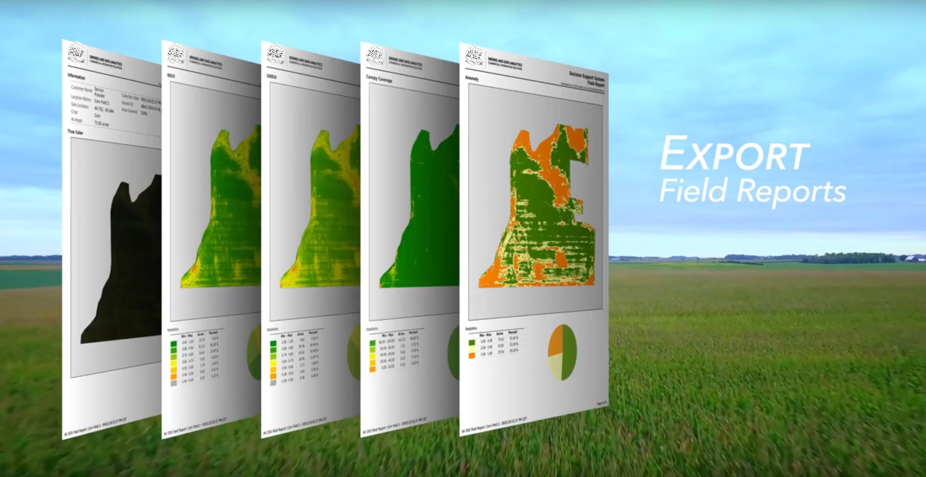
Exports and DataSets
Export all your datasets as PDF field reports so you can easily share insights.
Using this system, you can coordinate decision making and harvest the power of field intellegence.
Precision agriculture is not only about efficiency, but meeting global demands!
"Food waste during the production process is costly to the environment and economically. According to a McKinsey & Company report in 2016 on how big data will revolutionize the global food chain, about one-third of all food is lost during production each year globally in developing and emerging countries, while at the same time, 795 million people go hungry. Food loss and wastes cost about $940 Billion... "An RF-powered drone can help optimize resources such as fresh water, fertilizers, and pesticides as well as identify healthy and unhealthy crops and irrigation problems." Cited Forbes, Jennifer Kite-Powell, 2018

Contact us and join the pilot project this Spring!
If you would like to fly with us and be a part of this new vision and support our effort in precision agriculture, please contact our Owner/RPAS Pilot and Tech David Carlos by email or...
Call/text direct at 250.507.6421 

"Thank you. Please stay in touch to request a free consultation and recieve our emails with company news and announcements"
Call David Carlos, Owner VAP at 250 507 6421